Motivation
The complexity of clastic depositional systems and subsequent uncertainty of exploring and developing these types of reservoirs dictate the need for a source of rigorously collected, analyzed, and systematically organized data on clastic-reservoir architecture and depositional-system morphology, as well as regional context studies, modeling methodologies, and data collection techniques and tools. These data enable modelers, explorationists, and managers to assess risk, assign volumetrics, and design development plans optimized by analog data that are accurate for their own fields. Such data are often hard to come by.
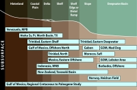 Depositional setting of QCLIA
study areas - subsurface studies - Click to Enlarge
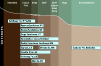 Depositional setting of QCLIA
study areas - outcrop studies - Click to Enlarge
To address this problem, we have created the Sedimentary ANalogs Database (SAND). SAND is a living catalog that is updated continually with new data as new outcrop and subsurface projects are undertaken by the our researchers. SAND is intended to be the most comprehensive collection of clastic-system images, animations, and data ever assembled. It is useful both as an introduction for novices, as a comprehensive source of analogs for experienced users, and as a repository of quantitative analog data to condition models for explorationists and developers. These data are available through annual subscription to the SAND Database and Research Program at Colorado School of Mines.
Goals
- To provide quality research observations, data, and products that are timely, pertinent, and easily incorporated into our sponsors' businesses
- To develop predictive models of clastic-system architecture, development, and response to change
Approach
The project team utilizes both small (hundreds of square kilometers) and large (thousands of square kilometers) 3D data sets to allow harvesting of clastic architectural data about various elements of the depositional systems. Seismic is investigated using techniques that employ conventional seismic sequence framework development, quantitative seismic geomorphologic analysis, various attribute extractions, harvesting of morphologic information, and export of these data into various programs for statistical analyses of temporal and spatial distribution and relationships.
The team also works with a significant legacy archive of outcrop data provided after decades of clastic-systems research at the Bureau of Economic Geology, as well as data from current outcrop studies. These outcrop results consist of thousands of detailed facies, lithology, and shale-architecture measurements, integrated with 100+ kilometers of detailed architectural drawings from photopanoramic images. Data sets include significant subsurface logs integrated with outcrop data, as well as porosity, permeability, and velocity measurements. These data are being harvested for the morphologic information that they document. Both seismic-derived and outcrop-derived data form the basis for probabilistic models of reservoir occurrence, character, and evolution. Results are conveyed to members as statistical data sets, modeling studies using both Schlumberger’s Petrel and Landmark’s Decision Space software and are combined with results from published works and previous studies to form a larger, searchable database (SAND).

Website
Contacts
Dr. Lesli J. Wood (This email address is being protected from spambots. You need JavaScript enabled to view it.)